AAM (Thailand) Co., Ltd.
QUALITY SURVEYING SERVICES
Surveying Services:

Ocean Marina


Ocean Marina
Land (Terrestrial) Surveys:
-
Topographic Survey
-
Dimensional Control Survey
-
High-Precision Control Networks Survey
-
GPS Survey
-
Volumetric Survey
-
Terrestrial Laser Scanner Survey
-
Mining Survey
-
General Land Survey for infrastructure, such as roads, dams, tunnels, rail, transmission line, canal, industrial estate, housing, resort
Hydrographic Surveys:
-
ADCP - Acoustic Doppler Current Profiler
-
Bathymetric Survey
-
Hydrological Survey
Aerial Surveys:
-
Aerial Mapping (Aerial Photography and Satellite)
-
Drone (UAV) Survey
-
Airborne Laser Scanner Survey
Topographic Survey

Hydrographic Survey

We carry out topographic surveys for a wide variety of clients. Projects have included land and industrial estate development, mining, hydropower, road surveys, railway surveys, and ground control for airborne LiDAR project. When required we also produce cross-sections, elevation, area and volume survey measurement. We also do interior and exterior measured building surveys. Software used is specially designed for efficient processing and display of survey data, which can be provided in industry standard formats such as AutoCad DXF and DWG as well as GIS data formats such as SHP and TAB where data is collected that contains multiple attributes.
GPS Survey

AAMT uses the latest in dual frequency GPS technology for survey tasks, including;
-
Static differential GPS survey measurements to establish precise three dimensional coordinates for rigorous survey control networks.
-
Real Time Kinematic (RTK) GPS survey measurements for rapid acquisition of three dimensional terrain data, RTK GPS survey is used extensively when appropriate for topographic survey.
-
GPS survey measurements are used extensively to provide spatial control for hydrographic survey.
GNSS characteristics;
220 channels with simultaneously tracked satellite signals
-
GPS: L1C/A, L1C, L2C, L2E, L5
-
GLONASS: L1C/A,L1P, L2C/A, L2P, L3
-
SBAS: L1C/A, L5 (QZSS, WAAS, EGNOS, GAGAN)
-
Galileo: E1, E5A, E5B
-
Bei Dou (Compass): B1, B2
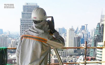
Building Survey
Hydrographic surveying includes nearshore, estuary, rivers, lakes and inland waterways. Services provided include bathymetry, tide and current measurements, profile and cross sections of rivers and watercourses, river gauge survey, We are experienced in survey and mapping of flood plains, and provision of terrain data required for flood studies.
ADCP (Acoustic Doppler Current Profiler)
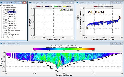
AAMT owns and operates Acoustic Doppler Current Profiler equipment, often referred to with the acronym ADCP. The instrument is used to measure the velocity and discharge volume of water moving across an entire water column. The ADCP measures water currents with sound, using a principle of sound waves called the Doppler effect. The ADCP works by transmitting 'pings' of sound at a constant frequency into the water. The pings are so highly pitched that humans and even dolphins are unable to hear them. As the sound waves travel, they ricochet off particles suspended in the moving water, and reflect back to the instrument. Due to the Doppler effect, sound waves bounced back from a particle moving away from the profiler have a slightly lowered frequency when they return.
Particles moving toward the instrument send back higher frequency waves. The difference in frequency between the waves the profiler sends out and the waves it receives is called the Doppler shift. By measuring the time it takes for the waves to bounce back and the Doppler shift, the profiler can measure current speed at many different depths with each series of pings.
Mapping (Photogrammetry)

AAMT carries out building surveys for a number of applications, including :
-
building construction
-
building maintenance
-
building renovation
-
building inventory
-
as-built building record
-
heritage building documentation and preservation
To carry out the building surveys, we will typically use high precision, 2 second angular resolution total station equipment, together with millimetre resolution static terrestrial laser scanner and / or centimetre resolution mobile terrestrial laser scanner.
The final output and deliverables are in accordance with clients specified requirements. These may include converting the Point Cloud Model into AutoCad Revit Model.
For selected areas, applications, and accuracies the use of photogrammetry for producing mapping, digital terrain, and digital elevation modeling is appropriate. The stereoscopic image acquisition platforms and methodologies that we utilise in our digital photogrammetric mapping include :
-
large format aerial photography from fixed and rotary wing aircraft
-
existing and archival aerial photography
-
programmed satellite imagery
-
existing and archival satellite imagery
-
unmanned aerial vehicle (UAV) aerial photography, also known as
-
drone aerial photography
Typically we utilise both Differential Static and RTK GPS survey for the establishment of required ground control points (GCPs).
Digital photogrammetry is a cost effective method for larger areas that require survey and mapping.